Friday, April 10, 2015

Day 398 — Ships in the vicinity


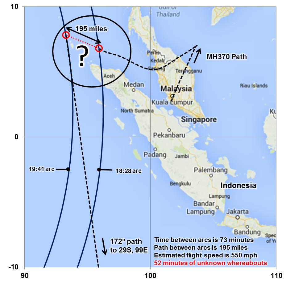
When Malaysia Airlines flight MH370 inexplicably changed course on 8 March 2014 and from all indications eventually flew to its doom in the southern Indian Ocean, it must have crossed paths with the shipping below. Mike Chillit (@MikeChillit) tweeted graphic archiving trackable shipping when MH370 crashed.

Note that the very closely spaced of the yellow dots do not in most cases indicate separate ships, but the same ship at each reporting interval during the day. The darker blue shading shows the priority search portion of the so called 7th arc positions from which an incomplete signal from an engine monitoring computer on board MH370 was sent to an Inmarsat satellite parked above the equator on the western side of the Indian Ocean at the moment 777 is believed to have struck the water after its fuel was exhausted.

Had any of the shipping that could have conceivably been under those possible flight paths noticed MH370 at the relevant times, it could allow the discarding or modification of some of the estimated flight paths and potential debris zones on the bottom of an ocean where the key areas have only just been surveyed so that they could be safely examined at closer range by towed deep sea sonar scanning devices.

Sunday, March 8, 2015

Day 365 — After one year

The Malaysian Safety Investigation Team for MH370 issued a factual report, exactly one year after the Malaysia Airlines Boeing 777 went missing.

The 584 page document details factual findings following examinations of ATC radar and radio recordings, maintenance records, cargo information etc.

The Investigation Team is now conducting analysis of the factual information and is considering the following areas:
  • Airworthiness & Maintenance and Aircraft Systems;
  • ATC operations from 1719 to 2232 UTC on 7th March 2014 [0119 to 0632 MYT on 8th March 2014];
  • Cargo consignment;
  • Crew Profile;
  • Diversion from Filed Flight Plan route;
  • Organisational and Management Information of DCA and MAS; and
  • Satellite Communications (SATCOM).
The report reveals that the battery powering one black box's locator beacon expired over a year before the incident.

The old battery means that crews searching the southern Indian Ocean likely wouldn't have picked up a signal from the black box even if they were floating right over it. In the weeks after the disappearance, crews searched hastily to try and find a black box before the batteries ran out of power. They're required to last at least 30 days after a crash.

According to the report, an error in maintenance records kept the battery from being replaced. Nevertheless, the flight data recorder would have continued logging data during the flight even if its locator beacon battery was dead. The battery for the other black box, the cockpit voice recorder, was up to date and search crews would have noticed its locator pings had they been in its vicinity.

Thursday, March 5, 2015

Day 362 — MH370 search could be scaled back

Australian Prime Minister Tony Abbott expressed hope missing Flight MH370 will be found, but suggested the search may be scaled back as he marked one year since it vanished.

"I do reassure the families of our hope and expectation that the ongoing search will succeed," Abbott told parliament in Canberra. "I can't promise that the search will go on at this intensity forever but we will continue our very best efforts to resolve this mystery and provide some answers."

Australia is leading the hunt in the Indian Ocean about 1,600 kilometres off its west coast, with four ships using sophisticated sonar systems to scour a huge underwater area. The vessels are focusing on a 60,000 square kilometre priority zone, with the search scheduled to end in May. More than 40 percent of the ocean floor has been explored to date. The intensive search - jointly funded by Australia and Malaysia with a budget of $93 million - has so far only turned up a few shipping containers.

"It's a very expensive search. We want to make sure that when we run over (a possible debris field), we know we don't miss it by accident," Fugro's MH370 search head Paul Kennedy said Thursday. "Because we'll never go back there again. It's a one-shot deal."

Tuesday, March 3, 2015

Day 360 — No debris, only shipping containers

The intensive underwater hunt for missing plane MH370 has so far turned up just a few shipping containers - and no sign of the jet, the head of the Australian agency leading the search said today. Chief commissioner of the Australian Transport Safety Bureau (ATSB) Martin Dolan said that while several manmade items - mostly shipping containers - have been detected during a sonar search, they had found nothing resembling debris from the Malaysia Airlines jet.

Australian and Malaysian authorities have narrowed the search area to a vast 60,000 square kilometre zone - and they have so far scoured around 40 per cent of it, Dolan said. The ATSB expects the priority area search to be completed in May 2015, but Dolan said it was too soon to say if the hunt could extend beyond then when weather conditions in the remote region worsen. “The decision about what’s next, which is hypothetical at this stage, is one for governments,” Dolan told AFP. “From our point of view... we’ve only searched 40 per cent of it, and our focus is on searching the rest of that area and we expect to find the aircraft there. We just can’t guarantee it will happen.”

The commissioner said search officials have categorised objects they found into three levels - with level one classed as items that have “at least some characteristics of an aircraft debris field”. So far the search has turned up eight “level twos” and more that 100 “level threes”, he said. “The sorts of things we’re tending to pick up are shipping containers,” Dolan said, which are defined as level twos, while level threes are usually geological features.

Wednesday, August 6, 2014

Day 152 — Fugro has won the tender of MH370's search

Dutch engineering firm Fugro will lead the search of the Indian Ocean seafloor where missing Malaysia Airlines Flight MH370 is believed to have crashed, hoping to unlock the greatest mystery in modern aviation.
Australia on Wednesday awarded Fugro the lead commercial contract for the search, after months of hunting by up to two dozen countries revealed no trace of the missing Boeing 777.
Investigators say what little evidence they have to work with suggests the aeroplane was deliberately diverted thousands of kilometres before eventually crashing into the Indian Ocean off the coast of Western Australia.

The next phase of the search is expected to start within a month and take up to a year, focussing on a 60,000 sq km patch of ocean some 1,600 km west of Perth.
Australian Transport Minister and Deputy Prime Minister Warren Truss said Fugro was selected after "offering the best value-for-money technical solution" for the seafloor search.
"I remain cautiously optimistic that we will locate the missing aircraft within the priority search area," he told reporters in Canberra.

Fugro will use two vessels equipped with towed deep water vehicles carrying side scan sonar, multi beam echo sounders and video cameras to scour the seafloor, which is close to 5,000 m deep in places. Fugro will spend more than $52 million in the next year in the search for MH370.
The Dutch company is already conducting a detailed underwater mapping of the search area, along with a Chinese naval vessel.
"We haven't completed the mapping, so we are still discovering detailed features that we had no knowledge of, underwater volcanoes and various other things," said Martin Dolan, the head of the Australian Transport Safety Board, which is heading the search.

Monday, July 14, 2014

Day 129 — Suspicions of systems tampering

The independent researchers are now drawing attention to data that implies that the jet, with 239 people on board, flew in a circular or complex path for 52 minutes off the northern tip of Sumatra before then flying an apparently straight course southwards for more than four hours before running out of fuel off the Indian Ocean coast of Western Australia.

That previously unrecognized period of 62 minutes of untraced flight begins with a ‘strange’ message from the ACARS computer on board MH370 to an Inmarsat satellite consistent with there having been a temporary interruption to normal electrical power on the jet.

The next, and apparently normal standby signal exchange between MH370 and the satellite 73 minutes later occurs at a point calculated by the official investigation to be only 195 miles further northwest and immediately prior to the jet turning south.

However at the speed assumed by the official inquiry, MH370 would have covered that distance in a straight line in 21 minutes leaving 52 minutes of flight time unaccounted for.

Thursday, June 26, 2014

Day 111 — New underwater search area announced

Australian officials released a 64-page report that concludes search operations should shift to an area 1,800 kilometers off the west coast of Australia.
Officials said they changed the search area after analyzing satellite data and that an underwater search would continue in the new area starting August. They also believe that the plane was on autopilot when it crashed.
"It is highly, highly likely that the aircraft was on autopilot otherwise it could not have followed the orderly path that has been identified through the satellite sightings," said Australian Deputy Prime Minister Warren Truss.
He announced a new high priority underwater search area for missing Malaysia Airlines Flight MH370. The new search area of up to 60,000 square kilometres is located in the Southern Indian Ocean and, like previous searches, is located along the seventh arc – a thin but long line that marks where the missing aircraft last communicated with a satellite.

Tuesday, June 17, 2014

Day 102 — New search area recommended

A group of 10 independent researchers released a statement detailing their findings and recommendations regarding a new search for missing Malaysia Airlines Flight MH370. The scientists pored over the 45 pages of raw satellite data that Malaysian officials released last week, and conducted their own analysis to determine the most likely crash site of the doomed flight. Five separate computer models all place the plane in a tight cluster of spots in the south Indian Ocean — hundreds of miles southwest of the previous search site. "We recommend that the search for MH370 be focused in this area," the group said in a statement. "While there remain a number of uncertainties and some disagreements as to the interpretation of aspects of the data, our best estimates of a location of the aircraft (is) near 36.02 South 88.57 East," according to the statement, which was approved by 10 named experts.

Thursday, June 5, 2014

Day 90 — The 7th arc

The latest information and analysis confirms that MH370 will be found in close proximity to the arc set out in the map and labelled as the 7th arc. At the time MH370 reached this arc, the aircraft is considered to have exhausted its fuel and to have been descending. As a result, the aircraft is unlikely to be more than 20 NM (38 km) to the west or 30 NM (55 km) to the east of the arc.
Refinement of the analysis in the coming weeks will reduce the underwater Search Area along this arc to a prioritised 17,500 sq. NM (60,000 sq. km). The prioritised length of the Search Area along the arc is expected to be 350 NM (650 km).

Wednesday, June 4, 2014

Day 89 — Underwater sound

Curtin University near Perth, Australia, on Wednesday released an audio clip captured by one of the listening devices, off of Perth. This underwater sound that they say could possibly be related to the final moments of missing Malaysia Airlines Flight 370.

The signal, which lasts just five seconds, was picked up by sound recorders off Rottnest Island just after 1.30am UTC on March 8.

"One signal has been detected on several receivers that could be related to the crash," said Alec Duncan with the university's Centre for Marine Science and Technology (CMST).

Researchers have been analyzing the very low frequency sound for weeks to see if it was "the impact of the aircraft on the water or the implosion of parts of the aircraft as it sank," Duncan said. "But (the source of the noise) is just as likely to be a natural event."
Low frequency signals can travel thousands of miles through water under favorable circumstances, at about 1 mile per second, Duncan said. But "at the moment (the sound) appears to be inconsistent with other data about the aircraft position," he said.

Tuesday, June 3, 2014

Day 88 — 'I saw MH370 on fire'

A British woman sailing across the Indian Ocean in March claims that she may have seen the lost Malaysian Boeing 777 aircraft on fire.
Katherine Tee was sailing from Cochin (India) to Phuket (Thailand) with her husband, Marc Horn, when she saw what appeared to be a large aircraft crossing the night sky, trailing a plume of black smoke.
Ms Tee was on night-watch on the couple’s 40ft sloop on the night of March 7-8 when flight MH370 vanished.
The couple have since re-checked their sailing logs and believe they were near one of the projected flight paths for the aircraft, which went missing on 8 March.
They have now filed a report to the Joint Agency Coordination Centre (JACC), the Australian government agency running the search for the missing airliner, with the full track data for their voyage.
Tee claims there were also other planes visible that night. "There were two other planes well above it – moving the other way – at the time. They had normal navigation lights. I remember thinking that if it was a plane on fire that I was seeing, the other aircraft would report it."

MH370 was carrying a consignment of lithium-ion batteries with a "flammability hazard" warning on the packaging, but experts had previously ruled out fire as a cause for the disappearance.

Thursday, May 29, 2014

Day 83 — End of the Bluefin-21 mission

The missing Malaysia Airlines plane is not in the Indian Ocean search zone where acoustic "pings" were detected, search co-ordinators have confirmed.

The acknowledgment came Wednesday as searchers wrapped up the first phase of their effort, having scanned 850 square kilometres of southern Indian Ocean floor without finding any wreckage from the Boeing 777-200. The Bluefin-21 was not able to look at one area in the northernmost ping area because of the depth of the water there.

Authorities now almost universally believe the pings did not come from the onboard data or cockpit voice recorders but instead came from some other man-made source unrelated to the jetliner that disappeared on March 8.

Australia said this week it will negotiate with private companies to conduct the next phase, which will resume in two months, if not later. That phase, which aims to scour about 60,000 square kilometers, probably won't start for at least two months.


This seafloor topography map illustrates jagged plateaus, ridges and other underwater features of a large area underneath the Indian Ocean where search efforts have focused since contact with Malaysia Airlines flight MH370 was lost on March 8.

The new illustration of a 2,000 kilometer by 1,400 kilometer area where the plane might be shows locations on the seafloor corresponding to where acoustic signals from the airplane’s black boxes were reportedly detected at the surface by two vessels in the area. It also shows the two plateaus near where these “pings” were heard.

It points out the deepest point in the area: 7,883 meters (about five miles) underneath the sea in the Wallaby-Zenith Fracture Zone.
Seafloor topography in the Malaysia Airlines flight MH370 search area. Dashed lines approximate the search zone for sonar pings emitted by the flight data recorder and cockpit voice recorder popularly called black boxes. The first sonar contact (black circle) was reportedly made by a Chinese vessel on the east flank of Batavia Plateau (B), where the shallowest point in the area (S) is at an estimated depth of 1637 meters. The next reported sonar contact (red circle) was made by an Australian vessel on the north flank of Zenith Plateau (Z). The deepest point in the area (D) lies in the Wallaby- Zenith Fracture Zone at an estimated depth of 7883 meters. The Wallaby Plateau (W) lies to the east of the Zenith Plateau. The shallowest point in the entire area shown here is on Broken Ridge (BR). Deep Sea Drilling Project (DSDP) site 256 is marked by a gray dot. The inset in the top left shows the area’s location to the west of Australia.

Tuesday, May 27, 2014

Day 81 — Ping transmissions: Ran out of fuel?

The Malaysian government has today publicly published the final ping transmissions between Malaysia Airlines Flight 370 and an Inmarsat satellite that it was communicating with before it disappeared - so now anyone can investigate what happened to the aircraft.


Based on the same data, the Australian Transport Safety Bureau has also issued a report explaining that the plane most likely descended to its fate after running out of fuel. That's based on calculations of how long it took the plane to descend and modeling of fuel burn for different flight paths. Flight 370's final digital handshake with the satellite didn't coincide with previous regular hourly transmissions. That is likely due to its electrical systems resetting when the plane ran out of fuel, the ATSB summary said. It's still believed the plane crashed into the southern Indian Ocean, though all searches to date have proved fruitless. The conclusion comes as Australia's naval vessel Ocean Shield abandons its search on Wednesday - and a week before authorities open up the hunt to private contractors.

Tuesday, May 20, 2014

Day 74 — New life born

Wife of MH370 steward gives birth to baby boy. Happiness and radiance were etched on Intan Maizura Othman's face with the arrival of her bundle of joy. But there was still an apparent sadness behind her happiness as her husband, Flight MH370 steward Mohd Hazrin Hasnan was not present to welcome their second child together. Intan Maizura Othman, the wife of Malaysia Airlines Flight MH370 steward Mohd Hazrin Hasnan, has given birth to a baby boy. Muhammad was born at 4pm on Monday, 73 days after Mohd Hazrin went missing together with 238 others on board the flight from Kuala Lumpur to Beijing. Born in Putrajaya Hospital, Muhammad is the second child of Mohd Hazrin and Intan Maizura, 34.

Friday, May 2, 2014

Day 56 — GeoResonance: False trace

Nothing has so far been found in the Bay of Bengal, with regard to a report by an Australian exploration company that it might have located the wreckage of the missing Malaysia Airlines (MAS) MH370 aircraft.
Joint Action Coordination Centre (JACC) Chief Coordinator Angus Houston said: "Currently three Bangladeshi navy ships were scouring the area, with one of the ships equipped with echo sound capability to assist in ensuring a thorough search in that particular area."
“But I will say very quickly that I have the heaviest weight put on all the evidence that is before us, the great work that the world team here in Kuala Lumpur has found, the analysis of the manual handshakes between the aircraft and the satellite."
“And also, the stimulation work has been done to define the area in the southern Indian Ocean. I’m confident the area in the southern (Indian) ocean is the right search area and I’m sure that in time, we will find the aircraft in that area of the Indian Ocean” he said.

More and more seems to be proven that the company GeoResonance pseudo-scientific method is not a real solution. Their "remote sensing" called unspecified technique mostly belong to the notion of quackery. Described with reference to flight MH370 "discovery" is a bad taste advertising, taking advantage of the international attention for the lost Malaysian airplane. Find more evidence here:

https://www.metabunk.org/threads/debunked-exploration-company-georesonance-believes-it-may-have-found-mh370.3558/

Thursday, May 1, 2014

Day 55 — MH370-ATC conversation

The Malaysian government has released the preliminary report with audio recordings of the communication between the cockpit and air traffic control on March 8 just before the aircraft lost contact.

Monday, April 28, 2014

Day 52 — New lead?

GeoResonance Ltd, a South Australian company and its team of scientists have invested considerable resources into the search for Malaysian Airlines flight MH370. The only motivation is to help the families of the missing passengers and crew, knowing the company has the technology capable of the task.
GeoResonance has discovered what they believe to be the wreckage of a commercial aircraft. The wreckage is located approximately 190km south of Bangladesh in the Bay of Bengal. The wreckage is sitting on the seabed approximately 1000m to 1100m from the surface. The company is not declaring this is MH370, however it should be investigated. The search was completed using proven technology. In the past, it had been successfully applied to locate submersed structures, ships, munitions and aircraft. In some instances objects that were buried under layers of silt could not be identified by other means. At present the technology is being used with great success in the mining exploration industry.
In order to identify and locate subsurface substances, GeoResonance Remote Sensing analyses super-weak electromagnetic fields captured by airborne multispectral images. During the search for MH370, GeoResonance searched for chemical elements that make up a Boeing 777: aluminium, titanium, copper, steel alloys, jet fuel residue, and several other substances. The aim was to find a location where all those elements were present.
GeoResonance commenced the search before the official Search and Rescue operation moved to the Southern Indian Ocean. The multi-discipline team of 23 researchers, including 5 professors and 12 PhDs got involved in the project. The search used the imagery taken on March 10, 2014, and was conducted consecutively in 4 zones north and northwest of Malaysia, until all targeted elements produced an anomaly in one place in the Bay of Bengal.
GeoResonance completed analysis of multispectral imagery of the location taken on March 5, 2014. It established that the anomaly had appeared between the 5th and 10th of March 2014.

Wednesday, April 23, 2014

Day 47 — Object of interest

Unidentified material that has washed ashore in southwestern Australia is being examined for any link to the lost Malaysian plane. Police secured the metal item, which washed ashore near Augusta, on the country’s southwestern coastline. The Australian Transport Safety Bureau is examining photographs to assess whether further investigation is needed and if the material is relevant to Malaysia Airlines Flight 370.


Next day the Australian authorities revealed that the "object of interest" found on the coast of western Australia is not related to the lost plane.

Thursday, April 17, 2014

Day 41 — No oil link

The Australian authorities said that an oil slick detected in the search zone and collected by the Australian vessel Ocean Shield was not engine oil or hydraulic fluid from an aircraft.

The sample was collected Sunday night more than three miles from the area where Ocean Shield had picked up underwater acoustic signals.

Monday, April 14, 2014

Day 38 — Go underwater

No underwater pulses detected in almost a week. Ocean Shield will cease searching with the towed pinger locator later today (Monday) and deploy the autonomous underwater vehicle Bluefin-21. It's a probe equipped with side-scan sonar -- acoustic technology that creates pictures from the reflections of sound rather than light. Each deployment will last 24 hours. It will take two hours for the Bluefin-21 to get down to the bottom of the ocean. Then it will scour the ocean bed for 16 hours, and take another two hours to resurface. It will take take another four hours to download and analyze the data collected.


The Australian ship Ocean Shield detected an oil slick Sunday evening, but it is unclear where the oil came from. A 2-liter sample has been collected for examination, but it will take a few days.